


‘Space Brolly’ Returns the First Striking Images of Earth’s Forests
‘Space Brolly’ Returns the First Striking Images of Earth’s Forests
The satellite aims to deliver the most precise global carbon cycle measurements to date
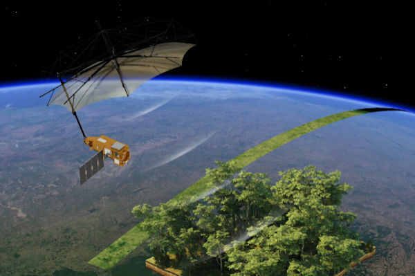
A giant umbrella-like satellite fitted with tech (dubbed the Space Brolly) has revealed its first images of Earth’s surface. Covered by Wood Central, the satellite uses an approach similar to a CT scan—slicing through the trees to create a 3D map, for the first time, of more than 1.5 trillion trees in remote, dense and dark rainforests.
The probe, known as “Biomass,” was built by various aerospace giants and startups for the European Space Agency (ESA). It launched in April on a Vega-C rocket from Europe’s spaceport in Kourou, French Guiana. European Astrotech, a UK-based startup, was responsible for fuelling the satellite ahead of takeoff.
Biomass’ mission is to capture the most detailed measurements of forest carbon ever recorded from space. To do this, it’s been equipped with the first-ever P-band radar to enter orbit. It aims to deepen our understanding of changes in the Earth’s forests and their impact on the global carbon cycle.
Built by Airbus, this radar instrument uses long wavelengths that can slice through thick canopies to reach the woody structures underneath, where most of a forest’s carbon is stored. Beyond forests, the probe can also map subsurface geology in deserts, the structure of ice sheets, and forest floor topography.
Biomass circles Earth in a Sun-synchronous orbit at an altitude of around 666 kilometres. It transmits raw radar data from its P-band instrument to ESA’s Kiruna ground station in Sweden, where the information is received and sent to processing facilities. There, the data is calibrated and transformed into usable scientific products such as biomass density maps and forest height models.
Once processed, these datasets are made accessible through a Multi-Mission Algorithm and Analysis Platform (MAAP), designed by Belgian tech firm Spacebel. The MAAP enables scientists worldwide to search, access, and analyse Biomass data directly in the cloud without needing to download massive files or manage complex infrastructure.
The giant umbrella directs radar pulses from the P-band radar instrument mounted on the satellite’s body to the forests below. When the radar signals hit Earth’s surface, they bounce back. The umbrella-shaped antenna, built by US space firm L3Harris, catches the returning signals and redirects them to the satellite. From there, the onboard systems process the data to create detailed 3D maps of global biomass and other features in the landscape.
Source: Wood Central